You do not need to walk the entire Roman frontier to enjoy Hadrian’s Wall. A carefully chosen section gives you time to follow its line across open countryside, explore a fort and pause when the landscape deserves your attention. The secret is to plan around terrain and transport together. A short-looking stretch on a map can involve repeated climbs, while an interesting archaeological site can easily fill the time you thought you would spend walking.
Choose the experience before the endpoints
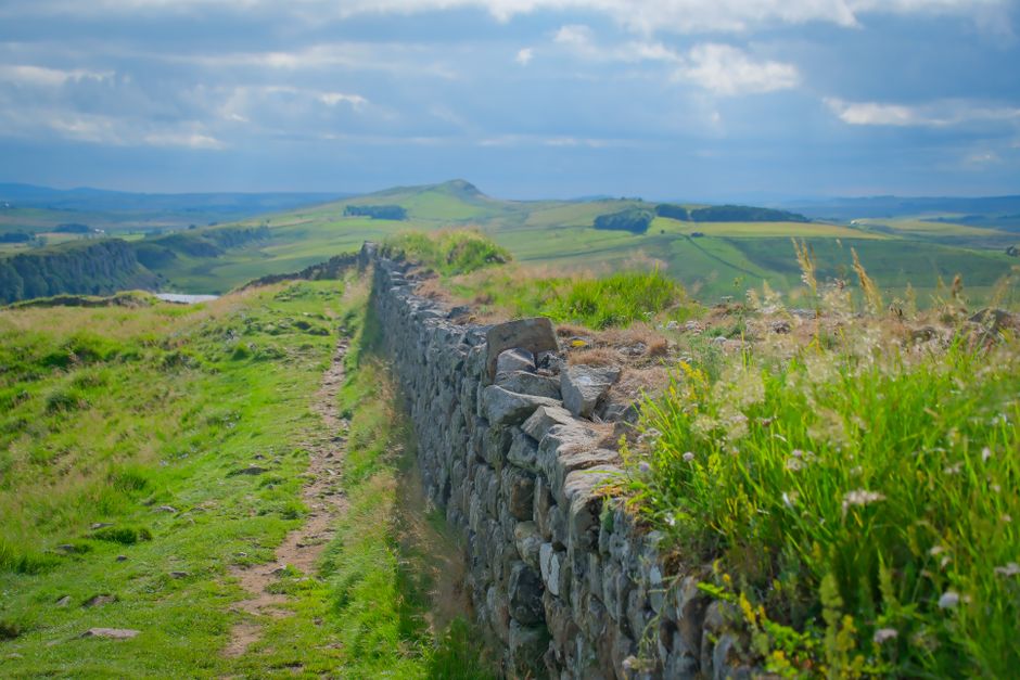
Start by deciding what matters most: dramatic scenery, Roman remains or an approachable first countryside walk. Hadrian’s Wall Path crosses varied landscapes in northern England, and surviving masonry is not continuous. Following the National Trail does not mean walking beside an intact stone wall throughout your day.
The central stretch around Housesteads and Steel Rigg offers the familiar combination of stone remains and rugged ridges. It also involves steep ascents and descents. Choose it if you enjoy hill walking, but keep your planned distance modest enough to appreciate the views without rushing.
For a different emphasis, investigate a section around Birdoswald and Gilsland, where the frontier’s remains and surrounding countryside provide plenty of interest. Inspect the precise route profile before committing: moving away from the central crags does not automatically produce a flat or step-free walk.
If mobility, balance or stamina is a concern, begin with official accessibility information for an individual heritage site. A shorter visit using suitable paths may work better than a point-to-point hike across fields, gates and uneven ground.
Decide between a linear walk and a loop
A linear section
Walking between two different points lets the landscape unfold without retracing your steps. It works well when both ends have dependable transport or when you have arranged a pickup. The essential planning step is to identify your finish first, including the exact stop or meeting place and how you reach it from the trail.
Where practical, take your transport to the starting point before walking back toward your accommodation or parked car. This can remove the pressure of catching a final departure after a tiring day. Still carry a backup plan if weather or a minor injury forces you to stop early.
A circular or out-and-back walk
A published circular route can simplify logistics, often combining a stretch beside the Wall with a return through different countryside. Use a recognised route description and a detailed map: a convenient-looking track may not be a public right of way.
An out-and-back walk is especially flexible. Set a turnaround point based on time, weather and energy, rather than treating a distant landmark as compulsory. Remember that reversing direction means climbing slopes you previously descended.
Build a day around effort, not mileage
Base your distance on recent walks over comparable ground. Smooth park paths are poor preparation for repeated stone steps, exposed ridges and slippery grass. If you are uncertain, choose a shorter section with room to extend it only when conditions and transport allow.
Write down a simple sequence: arrival, walking, heritage visit, food break and return journey. Include the approach from a bus stop or car park, any detour to accommodation and time to find the correct return stop. These connecting stretches are easy to overlook.
Choose one main heritage visit for the day. Housesteads occupies a commanding position beside the Wall, while Vindolanda lies away from the National Trail and needs separate access planning. Neither should be treated as a quick addition to an already demanding walk. Check official visitor information for access arrangements and allow time to look around properly.
Make transport and accommodation fit the route
The railway corridor through the Tyne Valley can help you reach the wider area, but a station is not necessarily close to your chosen trailhead. Plan the connection between railway, local bus and walking route as carefully as the main journey.
Check current timetables with transport operators, including operating days, seasonal changes and the last useful return service. Save the information offline and identify the precise stops. Do not assume that a bus passes every fort or that the return journey leaves from the same side of a road.
For a short break, staying in one base can be easier than moving accommodation each night. Compare the actual walking and transfer distances before booking. A property described as being near Hadrian’s Wall may still require a substantial detour from your section.
- Confirm how you will reach the trail on each walking day.
- Ask whether meals are available when you expect to arrive.
- Check any luggage storage or transfer arrangements directly.
- Keep a practical alternative for a shortened walk.
Choose a season with the ground in mind
Dry, firm ground makes walking more pleasant and helps protect the fragile archaeology beneath the turf. Take account of conservation guidance when choosing dates, and reconsider your route after prolonged rain. A flexible booking with a less demanding alternative can be more useful than a rigid itinerary.
Expect exposed conditions on the ridges. Wind can make a mild day feel cold, and wet stone requires deliberate footing. Check the local forecast shortly before setting out, then reassess conditions at the start. Short daylight leaves less room for delays, photography and unexpected detours.
Pack for an exposed countryside walk
Wear footwear with reliable grip that you have already used on uneven ground. Carry a waterproof jacket, suitable layers and protection from sun and wind. Trekking poles can help with repeated descents if you are accustomed to using them.
Bring drinking water and enough food for your planned walk plus a delay. Treat refreshments along the route as optional rather than essential. A charged phone, offline mapping, a backup map, a small first-aid kit and a head torch are sensible additions. Save accommodation and transport details before leaving reliable reception.
Navigate carefully and protect the remains
Follow the signed trail and check your map at junctions, particularly where access paths branch toward forts, roads or villages. Acorn symbols identify National Trails, but you still need to understand your intended route. Check current notices through National Trails and relevant land managers before departure, as diversions can change a familiar route description.
Do not climb onto masonry for photographs. Follow site-specific signs, leave stones where they are and avoid using fragile remains as seats or equipment supports. Keep gates as you find them, take litter away and give livestock space. If bringing a dog, check official guidance for the exact route and heritage sites beforehand.
A satisfying section hike leaves time to notice how the frontier fits the land. With a manageable distance, a confirmed journey home and one well-chosen historical stop, you can finish with a clear sense of the place and enough energy to enjoy the evening.